Atrás


-
Campo
Campo
-
50 ha
50 ha
-
Con alambrado perimetral
alambrado perimetral
Finca de 50 Hectareas a 20 Km de Barreal ceca a Cerro Alcázar
In front of the entry to the farm (on its eastern boundary) there is a relevant touristic point: the El Alcázar Mountain, a multiple-color rocky valley in the Andean foothills, with rock formations sculpted by the wind similar to those of the Valle de la Luna, but rather colorful. To its side and behind, the Andean foothills are magnificently displayed, with its mountains in a wide range of tones of brown, ochre, pink, violet and green, which color-schemes change throughout the day depending on the incidence of sunlight.
That area of the Andean foothills is an ideal place for horse riding or tour visits by car, motorbike or moped, a journey that may reach to the top of the Tontal Mountain (of approximately 4000 meters high), with views to the entire Calingasta Valley, the Aconcagua to the south and the valley of the city of San Juan to the east.
To the opposite direction -to the west- the majestic Andes Mountain Range can be seen, with its highest 6000-meter peaks (such as the Mercedario Mountain and other peaks of similar hight with their ever ending glaciers), that is to say, a mountain range of only 300 meters lower than the Aconcagua, displayed there in a panoramic view from the Farm.
There, trips to the Mercedario glaciers, to the Laguna Blanca or to Hornillas can be made so that, once there, horse-tours can be arranged to enter the Andes-mountain range and spend several nights up to the proximity to the limit with Chile, following the steps of the army of the General San Martin in the colonial days.
For rafting lovers, the Los Patos River offers rapids in a fabulous landscape of sheer red-stone walls, gently flowing afterwards through the entire Calingasta Valley and going along the edge of one of the boundaries of the Farm.
Another great touristic attraction in the area is the El Leoncito National Park, with its mud pampa -as flat as asphalt- plowed by land (car) sailing lovers powered by the furious Zonda wind.
And, in the night, the asteroid observation point offers to know a little more than just stars, as clear as nowhere else due to the lack of light pollution in the area and the scarce clouds in the limpid sky of San Juan.
Delimiting the Farm towards west, the Los Patos riverside is found, which main branch surrounds the Farm in approximately 500 meters.
2) Description of the Farm
2.1. Boundaries, constituting fractions.
As already mentioned, the Farm boundaries are the following: to the east, the route connecting Barreal with Calingasta, and to the west with the Los Patos River, surrounding the Farm with approximately 500 meters of shore.
The Farm is comprised by five fractions that, altogether, form a rectangle of almost 50 hectares.
In the upper part, and close to the route, the old trace of Route No. 412 is found, but it is not used by the public since it leads to anywhere as it does not end in a new trace; nowadays, it is an internal road of the Farm. The Farm has full wire fencing.
2.2 The slopes and their use
From the east boundary (over the route) the Farm expands towards west in a slope until the boundary with the shore of the Los Patos River. There are three differentiated levels:
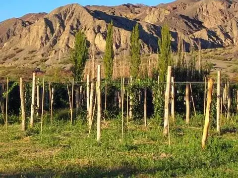
(a) in the upper part (to the east and bordering the route) the area of dwellings, fruit trees, an ancient grove, the vineyard and part of the alfalfa; this part is a type of balcony with a privileged view over the rest of the Farm which descends to the Los Patos River [Note: this upper part is approximately one third of the Farm];
(b) this is followed towards west by a few meters high ravine, at which foot water flows are originated with the natural forest of willow trees, popl
Ubicación
San Juan - ruta 100
Calingasta, San Juan
Características
-
Cant. Hectáreas: 50 ha
-
Casa Principal
Datos básicos
-
Tipo de operación: Venta
Instalaciones
- Alambrado perimetral
- Agua corriente
- Alambrados
- Electricidad
Servicios del Campo
- Electricidad
Código de aviso: ANTU942991[SP942991]_BAJA20200918